05-07-2013
 |
| La Sagra from south-west |
 |
| La Sagra from north |
Sierra de la Sagra is more of a single big mountain than a
range of mountains. It stands out and
can be seen from a long way, from many angles.
 |
GOML
|
In his book JM Hernandez describes a route starting from Los
Collados N37.97722 W56718 (1474m) There are two clues to show that you can no
longer access Sagra from here. One is the heavily padlocked and barb-wired gate
– the other I ignored at first because it was in Spanish and as you can see, in
the photo, clearly states the ‘nuevo’ access point is 2.5km down the road.
However, 2.5km down the road there is nothing to confirm that the unpaved road
is the one you need to take.
Indeed, other than signs about not picking flowers
much further up the hill there is no information anywhere.
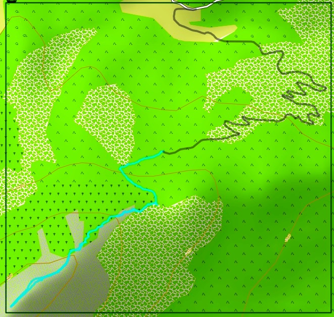 |
| My GPS tracks - grey for driving, blue for walking |
For the sake of other adventurers – turn north off the
GR-9100 road at N37.97640 W2.54549 (1405m) on to the unpaved road. There is
room for several cars at N37.96684 W2.54040 (1553m) and there is space for a
couple of cars at the end of the road at N37.96376 W2.54899 (1635m). From both
points there is a clear well used path that traverses uphill. At N37.96222
W2.55379 (1740m) the path meets what looks like could be the eastern branch of
the original path as shown in JMH’s book.
 |
| Above the Collado de las Viboras |
Turn left here and keep going up
through the trees and flowers to meet the ridge at Collado de las Viboras and a
welcome breeze at N37.95921 W2.54984 (1840m). Don't forget to turn right here
or you will end up in the valley on the other side of the Sierra. The path is
obvious throughout the next part of the route with a few scrambly bits.
 |
| False summit 1 |
 |
| False summit 2 |
Beware of false summits which come to you in sheeptrods, but inwardly they are raven’s lairs...
 |
| True summit |
The view from the rectangular trigpointed top of Pico de la
Sagra at N37.95008 W2.56536 is far ranging, pity about the heat haze. Note that
this is the sixth most prominent mountain in the Iberian peninsula with a
prominence of P1410, another 90m and it would be an Ultra but has to settle for
being a Major – I think there should be a category for anything with a
prominence of over P1000. It has an absolute height of 2382m.
 |
| La Sagra trigpoint |
I filled in the
summit logbook and descended by a route akin to the ascent one, if not a carbon
copy.
7.33 km 1128 m ascent
| Eigg transplant |
 Maria, I met a hill named Maria
Actually, I met a town, a sierra and a pico, all named Maria
– although there is clearly not consensus as to the name of the summit.
JMH describes the ascent of Maria/Alto de la
Burrica/Cerro Poyo as ‘facile’ – this lulled me into expecting a gentle stroll
on easy ground and unambiguous navigation. Not quite the case, but there was
nothing overly difficult really.
 |
| Penan de las Cuculas |
 |
| Ermita |
There is plentiful parking at the Ermita de la verging on
the ridiculous at N37.69165 W218031 (1360m). The road continues to the Jardin
Botanica at N37.68955 W2.18130 (1395m). If you want ‘facile’ go round the back
of the building and follow the unpaved road – with eventual contradictory signs
as to whether you can proceed or not. Do as I do and be prepared to argue that
you don’t understand Spanish and, anyway, the ‘satnav told me to come this way’.
I will explain more about this route later.
 I went up the track in front of the Jardin building and
fairly soon concluded that this wasn’t the ‘facile’ way. It was mainly the way
the tall grasses hit me in the face that put me off – however, being a tough
Yorkshireman I kept going. Basically, what you are doing is trying to follow a
dry stream bed without getting blocked by the frequent weirs and the vegetation.
I went up the track in front of the Jardin building and
fairly soon concluded that this wasn’t the ‘facile’ way. It was mainly the way
the tall grasses hit me in the face that put me off – however, being a tough
Yorkshireman I kept going. Basically, what you are doing is trying to follow a
dry stream bed without getting blocked by the frequent weirs and the vegetation. Eventually, at around N37.68056 W2.18257 (1660m) you meet a path with an
endless series of zigzags that takes you to Cdo de Portalchico at N37.67642
W2.18298. Some of those zigzags are obvious (and tedious) some have been
destroyed by people taking shortcuts (because they are tedious).
Eventually, at around N37.68056 W2.18257 (1660m) you meet a path with an
endless series of zigzags that takes you to Cdo de Portalchico at N37.67642
W2.18298. Some of those zigzags are obvious (and tedious) some have been
destroyed by people taking shortcuts (because they are tedious).From this point the path is less obvious. There is a line of cairns. But I know I did not follow them or their logic. Note that all the time, the views are great – shame about the heat haze. And, of course, don’t let the false summits get you. What’s the difference between a summit and a prophet? Some summits are true.
 |
| Cerro Poyo trigpoint |
I knew, ‘facile’ or not, I did not fancy returning down
those endless zigzags, there had to be a more direct route and who cares if it meant that it became more
‘median’. I backtracked to N37.67506 W2.19752 and then made a beeline to meet
the legit path at N37.68302 W2.19004 (1690m).

What I should have done is head for N37.68720 W2.19390 because that would have cut out one of the longer zigzags in the path that eventually ends up at the back of the Jardin building. OK, I confess I probably broke the local access code, I climbed over two or three fences than and I stumbled through odd bits ofvegetation, but at least I did not get as fed up as I did with the long sweeps of zigzagging I met lower down. The route has clearly been devised to ensure that you do not break out into a sweat. But, hey, if you are going to go up or down these slopes in the summer then you are going to sweat anyway. JMH is right the easiest ‘facile’ way is the track that starts at the front of the Jardin and follow the fence, upwards.
What I should have done is head for N37.68720 W2.19390 because that would have cut out one of the longer zigzags in the path that eventually ends up at the back of the Jardin building. OK, I confess I probably broke the local access code, I climbed over two or three fences than and I stumbled through odd bits ofvegetation, but at least I did not get as fed up as I did with the long sweeps of zigzagging I met lower down. The route has clearly been devised to ensure that you do not break out into a sweat. But, hey, if you are going to go up or down these slopes in the summer then you are going to sweat anyway. JMH is right the easiest ‘facile’ way is the track that starts at the front of the Jardin and follow the fence, upwards.
11.20km 1056m ascent.
Overnight in a free motorhome site in Velez Rubio, Almeria province – with free electric hook-up. (823m)
Then lots of driving to end up overnight at another free motorhome
site in Segorbe, Castello province – no electricity, but nice palm trees.
(324m)
No comments:
Post a Comment